
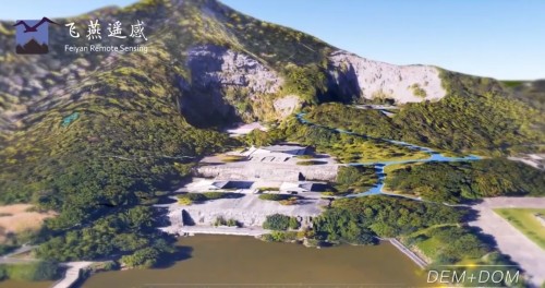

Aerial Integrated Multi Sensor
The construction of metaverse or 3D scenes is inseparable from basic data, and the richness and quality of data are the keys to determining products. Therefore, as a company specializing in aerial remote sensing for 20 years, Feiyan Remote Sensing have launched the "AIMS Aerial Remote Sensing Solution" here
Aerial Integrated Multi-Sensor(AIMS), as an IR&D equipment, contains 5 major modes, 10 sensors and a high-precision POS system. The pixels are as high as 880 million, of which the orthophoto can reach 280 million pixels. It can carry high-speed, fixed-wing aircraft to achieve excellent data acquisition efficiency.
Through the AIMS aerial remote sensing solution, all common aerial remote sensing data such as oblique 3D images, large-format digital aerial images, laser point clouds and hyperspectral images can be obtained at one time. It can express following information such as lines, rod-shaped features, under-forest topography, water areas, and tree forms, that cannot be accurately expressed in three-dimensional reality.


EDTA ACID $ 0.00
FIBERGL ASSTELE $ 20.00
0.96 INCH TFT DI $ 100.00

1.0mm Implants a $ 125.00

100 GSM Fast Dry $ 100.00
| Comment | ||
| Comment on the content: | ||
| Enter verification code: |
|
|