
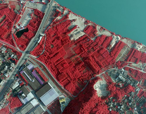
Color Infrared aerial photography can not only be used to document changes to the environment, the health of forests, wetlands, bays and oceans, but also to document and monitor such items as damage to roofs, the tracking of dairy farm out flows, pinpointing the source of, and monitoring, insect or disease infested vineyards, or sites contaminated by toxic chemicals, and more other applications.
Infrared film and infrared digital sensors are sensitive to a certain portion of the spectrum of light, and by careful filtration, processing and selection of films, infrared aerials can provide invaluable information. Please contact us to get additional information about color infrared aerial photography.
Most infrared aerial documentation involves the creation of vertical infrared aerials. Combined with orthorecitification techiques, comprehensive infrared aerial maps can be created which can be invaluable both for planning and monitoring purposes.
Specifications of Color Infrared aerial photography
Sensor: UCX
Resolution: 0.5m
Project area: 4071.3km²
Duration: 1month
Output: true color, full color, infrared (data)
Application: pine wood nematode disease surveillance
From: Jinhua City, Zhejiang Province
EDTA ACID $ 0.00
FIBERGL ASSTELE $ 20.00
0.96 INCH TFT DI $ 100.00

1.0mm Implants a $ 125.00

100 GSM Fast Dry $ 100.00
| Comment | ||
| Comment on the content: | ||
| Enter verification code: |
|
|