
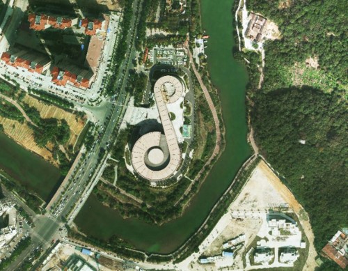
Orthophoto Processing
Feiyan Remote Sensing specialises in high-resolution orthophoto map processing including digital orthophotos and orthophoto mosaics from raw aerial survey photography and digital image capture. Orthophotos combined with a topographic mapping project give a precise reference backdrop tool that enhances the users understanding of any project area. Combined into orthophoto mosaics the imagery can cover large areas such as a catchment, river basin, highway or even local government area.
Process of Orthophoto Data Processing
Orthophoto data processing is the process of converting aerial photographs into a georeferenced and orthorectified image, which can be used in geographic information systems (GIS) or other mapping applications. The steps involved in orthophoto data processing typically include the following:
â— Image acquisition
Aerial photographs are taken using a camera mounted on an airplane or drone.
â— Image calibration
The photographs are calibrated to account for camera distortion and other factors that may affect the accuracy of the resulting image.
â— Image matching
The photographs are matched to each other to create a seamless mosaic of the entire area being mapped.
â— Digital elevation model (DEM) creation
A DEM is created using LiDAR or other data sources to provide information on the elevation of the terrain.
â— Orthorectification
The aerial photographs are orthorectified using the DEM, which involves correcting for perspective distortion and other effects to produce a map-like image that can be used for accurate measurement and analysis.
â— Color balancing
The colors of the orthophoto are balanced to ensure accurate representation of the terrain and objects being mapped.
â— Quality control
The orthophoto is reviewed for accuracy and any errors or issues are corrected.
EDTA ACID $ 0.00
FIBERGL ASSTELE $ 20.00
0.96 INCH TFT DI $ 100.00

1.0mm Implants a $ 125.00

100 GSM Fast Dry $ 100.00
| Comment | ||
| Comment on the content: | ||
| Enter verification code: |
|
|